37 Years Of Professional Aviation Experience.
Our qualifications:
BAZL (Switzerland) SORA UAS Operational Authorisation
BAZL (Switzerland) Open (A1/A3/+A2) and Specific (STS-01/02) Remote Pilot certificates
FAA (USA) Part 107 Remote Pilot certificate
ISO 18436-7 Cat 1 Infrared Thermography course certificate


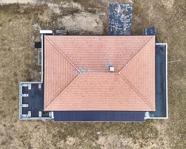
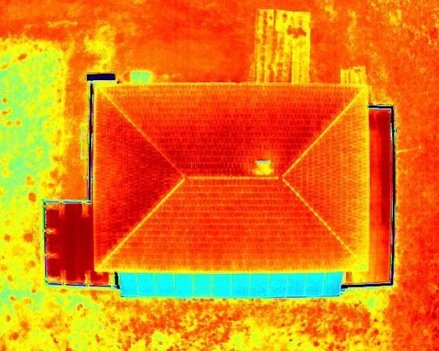
Visual and thermal wavelengths images of the roof of the Langlaufzentrum building near Biel, Switzerland, taken by Parhelion Aerospace.
What We Do:
We specialize in conducting aerial buildings inspections and solar panels inspections, using drones equipped with visual and thermal infrared cameras.
For buildings inspections, we provide high resolution visual and radiometric thermal IR imagery for analysis and modelling by our partner Inspekt AI, a US-based international firm, using their proprietary AI technology. This collaboration helps building owners and managers save money by identifying defects that could become more expensive to repair over time and pinpointing areas where buildings are experiencing costly energy leaks. Our approach is not only quicker but also more cost-effective compared to traditional inspection methods. Read our article about the importance of inspections in reducing energy wastage and greenhouse gas emissions.
For solar panels inspections, we use the same ultra-modern drone and camera equipment to conduct aerial thermal IR investigations that search for and identify cells and panels that are becoming defective. Owners can thereby manage the maintenance of their solar arrays with greater timeliness and efficiency, thus saving money and keeping the power output at full as much as possible.

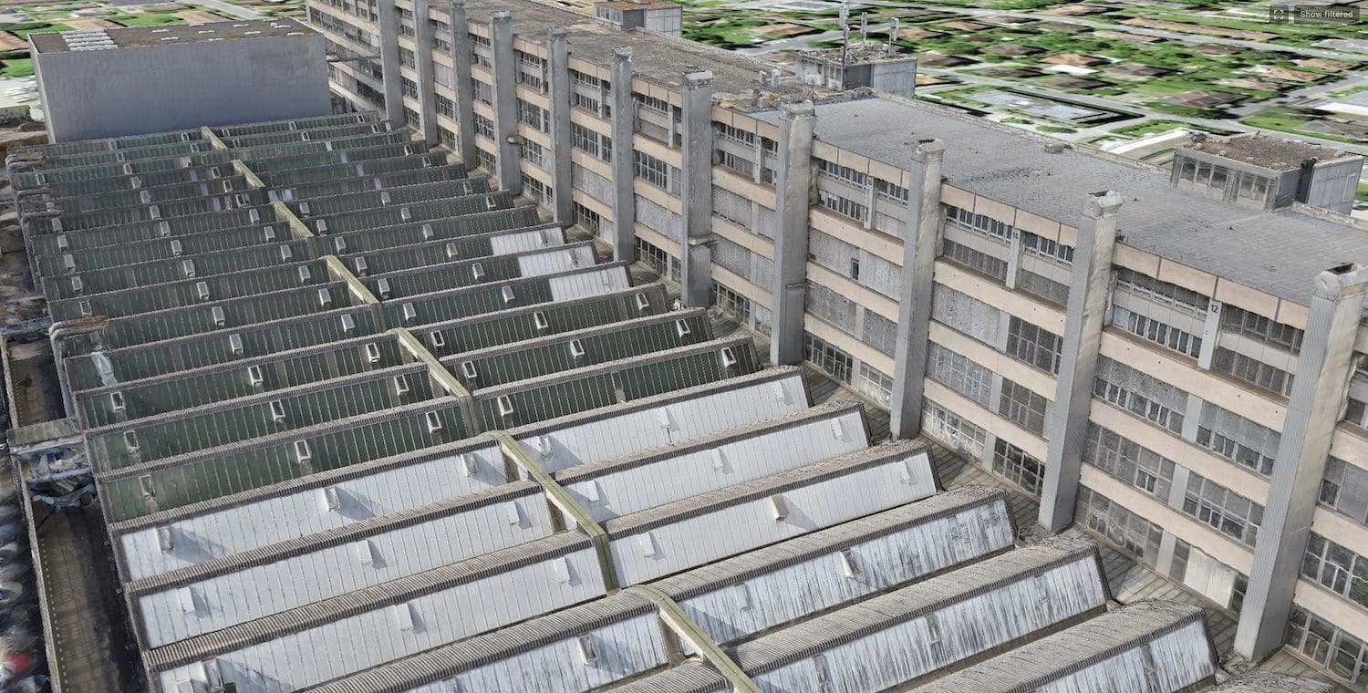
Part of an enormous 3D model made by Inspekt AI, using aerial data provided by Parhelion Aerospace, for a recent inspections project in Bern.

A composite image (RGB and thermal IR) of a large solar array on the roof of a barn. The thermal inset shows a section of panels that has an obvious defect (the bright cell near the bottom).
Contact us about inspecting your property.
What Else We Do:
Other than inspections, we are happy to work projects for private individuals as well as with companies that have sites for which they need aerial data (e.g. photos, videos, maps, stockpiles measurements). The uses of such data include monitoring changes in your work environment or in construction project progress, acquiring whole-site or site-elements images for public relations and advertising purposes, monitoring the status of rooftop conditions or of farm crops, property sales, website imagery, support for insurance claims and many more. Essentially, if you need to see your site (or home) from above, we can offer you quick, reliable service at an affordable price.
A sampler video showing some of our (other than inspections) work. For additional examples please visit our Youtube channel.

We can do cut and fill measurements that allow you to confirm that you got the volumes you paid for.
Parhelion also publishes a variety of drone logbooks for professional and hobbyist operators. We offer a selection of UAV Pilot Logbooks and are the first to publish dedicated UAV Aircraft Logbooks in which you can record and keep track of your machine’s maintenance, current condition and use history.
Contact us about arranging custom drone imagery / data for your location.
Who we Are:
Parhelion Aerospace brings over 35 years of professional aviation industry experience to the relatively new world of drones operations. Our past work experience with standard aircraft informs our present work with UAVS: we apply here the same rigor that characterizes the world of professional aviation in general. As a consequence our aircraft are properly maintained, our pilot is well trained, our flights are thoroughly planned, airspace use, insurance and legal considerations are meticulously observed, and all flights are conducted safely. Our mission is to set a standard of operational professionalism that will lead the drone services industry here in Switzerland. Parhelion Aerospace is a Swiss Bundesamt für Zivilluftfahrt (BAZL)-registered drone operator company. Zurich AG insures our operations for liability, in accordance with Swiss law.
We are a member of the Swiss Property Owners Association.
Our Pilot:
Michael Rampey is a BAZL – registered drone pilot who is fully trained and certificated for the work that we do: he has the Swiss (BAZL) A1/A3+A2 and STS-01/02 Remote Pilot Certificates, the USA (FAA) Part 107 Remote Pilot Certificate and the ISO 18436-7 Cat 1 Infrared Thermography course certificate. Our pilot is skilled not only in the use of our own equipment but has considerable experience flying the Swiss-made Wingtra UAV (a flying-wing design) and the Matrice 300 RTK, doing professional piloting work for the Zurich-based firm Nomoko, a digital-twin creator. He has the EASA and FAA Airline Transport Pilot licenses and many years of experience flying jet aircraft around the world, so he is very familiar with safe and professional procedures for the use of flying machines.

He has, additionally, a Ph.D. in Volcanology from the University of Cambridge, UK. Mike has worked on remote sensing, mapping and infrared imaging science projects and expeditions in several locations around the world.
The Equipment We Use
For inspections we fly the Mavic 3T (thermal) drone. This professional-grade aircraft is perfect for the buildings inspections mission: it is small, quiet and highly maneuverable. It possesses three cameras, one of which is a very capable radiometric thermal imager. It is able to take coordinated visual and thermal images of the same place at the same time. The Mavic 3T, moreover, has the latest in safety and obstacle avoidance capabilities.
We also fly the Mavic 2 Pro and the Inspire 2 professional-grade drones, for photography, mapping and videography purposes. The Inspire is equipped with the X5S camera and an array of high-quality Olympus and DJI lenses. The Mavic is equipped with a Hasselblad camera and is capable of shooting 20 megapixel photos and H.264, 4k Ultra-HD videos.
We can make color photographs up to poster-size at 20.8 megapixels. Video data are most commonly delivered as H.264, 4k Ultra-HD, but we can deliver Ultra-HD data up to 5.2K. Additionally, for those who require more post-processing latitude we can deliver your data in D-Log ProRes 422HQ. Samples of our work are presented on this page; in fact, all of the images and video on all of the pages in this website are our own shots (except where stated).

From left to right: our Mavic 2 Pro, Inspire 2 / X5S, and Mavic 3T (thermal) drones.
Where we Are
Parhelion Aerospace is based in the Seeland area of Switzerland, near the city of Biel and at the foot of the Jura mountains. We are therefore centrally located and can support projects throughout Switzerland and the nearby regions of France and Germany. For the right sort of project, however, we will travel the world!
We sell our logbooks online and so they are available anywhere.